|
New trails are in the works for Kanopolis
Lake!
Watch the home page for more information .
| Kanopolis Lake |
|
|
| tough technical |
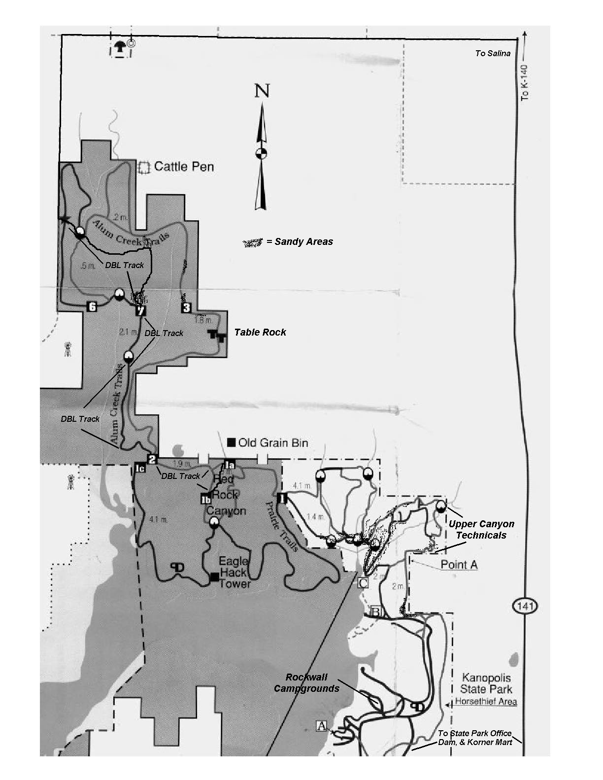
Kanopolis Lake Trail System~
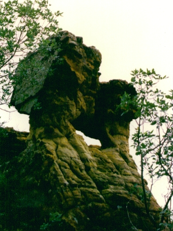
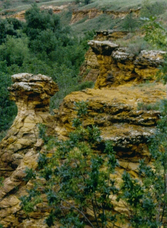
Kanopolis Lake has a sizeable
multi-use trail system. 24.9 miles of trails pass through sandstone rock formations,
tall bluffs and rolling hills. Not all of the 24.9 miles is exactly bike friendly,
but the ones that are make it a worthwhile destination. I have logged several
miles on these trials and with this page I will pass on some of the knowledge I have acquired so you can make the most of
your trek. Various loops and terrain can make a ride at K-Lake anything from easy recreational riding, to an epic adventure. The paragraphs below contain some details and information on K-Lake's trails. I will follow up with a map marked for preferred routes and directions on this page
at a later time.
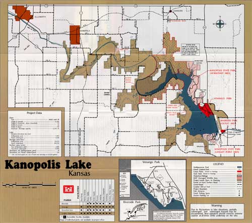
Kanopolis Lake has a Legacy Trail
self guided auto tour that will take you by 27 points of interest like Farris Caves, Mushroom Rock Park, and Fort Harker. A museum resides in the guardhouse of Fort Harker where Buffalo
Bill Cody and Wild Bill Hickok served as scouts in the late 1800s. Kanopolis
State Wildlife and Parks have informative brochures to guide you along this almost 80 mile tour around Kansas's oldest man-made
lake.
The Parks department also has some excellent trail maps. They have
done a very good job marking the multi-use trails with yellow T posts and color coding.
The maps are available at the Park Office, gate booths when open, the south shore area at the Marina, and at the biggest
little store around, Venango Korner Mart on the north end of the dam. While
in the Rockin' K area check out the trailhead artwork done by team LATR member Brian Holdsworth, wooden
beams and cross supports joined together by a large metal dreamcatcher, very cool.
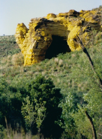
Horsethief Canyon~
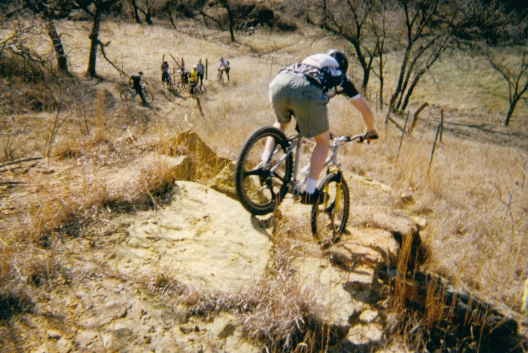
There are a couple of different places to access Kanopolis Lake's trails. The most common day use area is presently Area C in Horsethief Canyon. Directly to the south of the parking lot are two trails. The
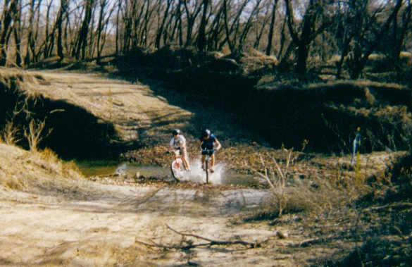
right (purple) trail is Buffalo Tracks Canyon Trail, a hike only trail, 1.5 miles long and worth the time off your bike. Go exploring or take the kids they will enjoy the caves and rock bluffs. Just leave your carving tools at home there is more than enough graffiti on the rocks already. The left trail is the continuance of the Blue trail that starts a mile or so to the south. It is sandy but the quickest route into the better bike trails of Red Rock Canyon and Alum Creek. You will have to hike/bike through some of the more formidable sand and at least one
water crossing. Sometimes this crossing can get a little deep. If it is more than you are prepared for you can continue along the hike trail, (off your bike) to a better
crossing between two of the caves. You will have to bike/hike through some more
sand after the crossing but eventually the ground firms up and some good riding is just around the corner. These trails are covered in the Epic Section at the bottom of this page.
To the East of the parking lot there is a trail heading up a short climb and into
the upper canyon area. This is some fun semi technical riding but a better place
to come out of the trails than to go in. Area C lacks bathroom and changing facilities
you may need after an epic ride. For longer rides I generally park
further south of this trailhead at Rockwall campgrounds.
Rockwall is a nice campsite
area with concrete shelter pads and tables. The Equestrian campground, Rockin' K is just to the south of Rockwall. It has nice shower facilities and is within easy bike distance either by road or trail. Be courteous and keep some distance between yourself and the equestrians.
Some horses do not care for them funny colored jersey's we all like to wear.
The Blue trail crosses the entrance road to the campsite and is a nice place to head north into Horsethief and the
remainder of the trails. You can pick up the Orange trail by following the paved road
south towards the horse park. Both routes add some miles to the trip with some
tough technicals and sand between you and miles of trails further out.
Take plenty of water and a map, if you intend to go the entire route. Depending on water, weather, and dumb luck
it can sometimes turn into an almost epic adventure.
The Blue and Orange trails are mostly
easy grassland trails with occasionally moderate hills. If you take the Blue
trail north approximately 1 mile out the blue trail will fork off into two trails. Follow the green trail (right fork)
at the Y across the road and north until it intersects with the orange trail.
At the Orange trail, a right turn will loop you back around to
the Rockin' K campgrounds on easy open field trails for an easy anaerobic work out.
I avoid riding the trails around the horse park if equestrians are camping there. Follow the road a short distance
around the camp area and rejoin the trails north of the bathrooms or asphalt it back your departure spot.
A left at the Y junction will take you to a wicked
downhill, through a bit of sand at the mouth of the first cave. After a short
hike/bike section you climb back to firmer footing through open pasture to the Canyon rim's technical section. It is semi technical with inspiring views and a few ledge hugging trails. It will take Sport class or better skills to successfully negotiate this section without walking. The end of this section brings you to another good down hill skills test and this routes first water crossing. If you are looking for a shorter ride this is a good spot to turn around and retrace
your route back along the canyon.
On the return trip after you clear the canyon rim and turn south
along the fence again take a right at the first junction, it will lead you out to area C's parking lot for some tough road
work back to where you crossed the road earlier. You can rejoin the trails there for the dirt track back to
your vehicle, or follow the road back for an asphalt workout. Approximately 3
to 5 miles depending on the route you take, easy to very technical along the rim.
Now for the epic
part...
Western Horsethief,
Prairie, and Alum Trails;
If you started out in Area C you are probably just getting started. You're still fresh, but you've pushed your bike more than you have ridden it. Things are going to get better. If you started out at Rockwall
and did the upper canyon loop you have done a few miles already. This sand section
is a good spot to grab a bar and catch up on the water reserves.
As you round the sandy point where the Orange and Blue trails
meet you will see another Y in the trail. In low water times the left fork will
get you quickly across the next creek and closer to the firmer ground. If this
crossing is too high take the right fork to the northwest. After a few more yards
of sand this trail firms up and winds further upstream to a usually more manageable water crossing. After crossing the creek and scaling a small rock embankment, (told you it was Daniel Booning with a bike),
continue following the trail northwest along the Orange trail.
The trail runs along the top of one of the many ridgelines and meets up again with the Blue trail after a sweet technical
descent. At the bottom of the hill, I prefer to turn right and continue on north
along the base of some inspiring bluffs. A short distance later the trail crosses
a dry creek and heads back to the south through a wooded section some of us call Poison Ivy alley. A twisty wooded trail ending in a technical rock canyon ascent., I generally prefer to use this same
route out. The Blue trail option to the south is a shorter route with a high
speed downhill. It is a good route out but between the hill and some more sand,
not the most fun to climb going in. Both trails meet again at gate #1.
Gate
#1 is where the biking starts to get real and the hiking a bit less frequent. The
trail to the north is the Orange trail it follows the fence line for a bit
then heads back south to a place bikers know as "Hanson Hill". The map shows
a shortcut marked 1a, if you are in a hurry to get to the service road and Alum Creek's trails this is a shorter, but
half hiking bypass. The trail to the south is the blue trail, a longer route,
it takes you toward the lake for some nice views and fun trails. It meets back
up with the Orange trail again at the bottom of Hanson Hill and another
water crossing. This one has concrete bags for a base as well as some brick pieces. If the water is too murky to see through use caution rolling through this crossing. Sticking a wheel between a couple of cement bags or hitting a brick at slow speed
can mean getting wetter than you planned. After you negotiate the water crossing
on the Orange trail you are facing a climb I refer to as Chimney Rock climb. It got this name from all the bricks youll see as you grind your way up this seemingly
unending climb. The Blue trail meanders south climbing the same hill a bit at
a time, looping near the lake on a fairly uneventful section of prairie trails for those of you that just want more miles.
The top of chimney rock climb leads you up to gate 1b. On the other side of this gate there are several trails and paths that warrant exploring if you have the
time and energy. The Orange trail north has
now turned into some fast double track that leads you quickly through gate #2 and onto gate #7 in the heart of Alum Creek. At gate #7 the trail turns left (west) along the fence line and meets up with
the service road again near the hunters gate parking lot. I prefer to continue along
the service road double track through another gate and down to the final water crossing.
Just before the water crossing the Orange trail goes north into the trees. If you find yourself ready to turn back this is a good place start, catch the trails
and begin your eventual return to civilization. If you are still up for more
miles cross the creek and follow the double track on to the hunters gate.
The
Hunters' gate, this is about as far into the backwoods trails as you can get.
This is also a good place for a pick up if you bit off more than you can chew, and you left a friend at your vehicle
you can communicate with. I know, I know, that would require a large amount of
prior planning and we bikers are not exactly famous for prior planning. Seriously
if you would like to ride the back trails and going through all this both ways is too much for you; this is a good spot for
a planned prior pick up. My friends and I do one-way ride throughs quite a bit. This location always figures into the planning.
At the gate the trails continue north for a short distance and then double
back along the tree line to the water crossing you just came through. At the
water crossing a yellow T post marks the entrance to the Orange trail. This trail is winding, with some tight technical, a definite challenge. If you follow it all the way it will lead you through trees, pastures, bluffs and impressive table rocks. Challenging singletrack winds around and up and down ravines before meeting up with
the Blue trail again at gate #2.
The route back is your choice among all the routes described above. Depending on where you left from and your choice of routes the ride can vary in length from15 to 20 miles. All routes will test your skills and conditioning, some may test your patience. Be prepared and self sufficient. There
is no place along the trails to refill water packs or re-supply so be prepared. An
Epic journey from Rockwall to the north gate and back can take between 2 and 4 hours depending on your skills and schedule.
Call or e-mail me if you are interested in a guided bike tour through the area. Call the State
Park office if your group is interested in one of their very informative guided tours through the Buffalo Tracks trails
T~
|
|
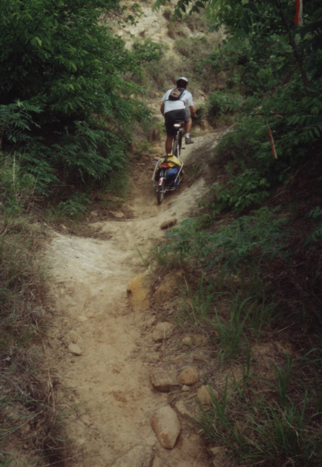
| Pullin' B.O.B. through K-Lake |
For more information on Kanopolis Lake visit the official
website.
If you would be interested in helping with trail maintenance or improvements
|


